VDOT’s Greenville Avenue road diet will rebuild 0.92 miles of Route 11 in Staunton with one travel lane each way, turn lanes and medians, buffered bike lanes, finished sidewalks, and safer crossings. Public comments close November 8, 2026. Here’s why the design works and how to support it.
By Kyle Lawrence, Executive Director, Shenandoah Valley Bicycle Coalition
TL;DR · Key Takeaways
The Virginia Department of Transportation (VDOT) plans to reconfigure Greenville Avenue (Route 11) in Staunton between Statler Boulevard and Commerce Road from five lanes to one travel lane in each direction, with left-turn lanes, medians, buffered bike lanes, a shared-use path, new sidewalks, and crosswalks. Federal research finds this kind of “road diet” cuts total crashes by 19 to 47 percent. The public comment period closes November 8, 2026, and you can weigh in through VDOT’s online survey.
In February 2019, a member of VDOT’s study team tried to walk across Greenville Avenue at Gay Street. There was no gap in traffic. The only way across was to run.
That moment is written into VDOT’s own corridor study, and it’s the reason this project exists. Greenville Avenue carries people to Bessie Weller Elementary, to the Kroger at Statler Square, to bus stops, to downtown, and home again. Right now it’s built as a five-lane highway through a neighborhood. The redesign makes it a street that works for everyone on it, including the people in cars.
Take VDOT’s Survey by November 8
What is changing on Greenville Avenue?
The project covers 0.92 miles of Greenville Avenue (Route 11) between Statler Boulevard and Commerce Road in the City of Staunton. Today that stretch has two through lanes in each direction plus a two-way center turn lane.
Under VDOT’s design:
- One travel lane in each direction for motor vehicles.
- Dedicated left-turn lanes at the main intersections, including Ritchie Boulevard, Bessie Weller Drive, Gay Street, and Hampton Street, so turning drivers wait out of the travel lane.
- Grass and concrete medians replace parts of the center turn lane to reduce the number of places where drivers turn across traffic.
- Five-foot bike lanes with a four-foot buffer from Statler Boulevard to just south of Richmond Avenue.
- A shared-use path from Richmond Avenue to Commerce Road, connecting to the Commerce Road path scheduled to start construction in 2027.
- New sidewalk to close the gaps between Statler Boulevard and Commerce Road, plus crosswalks and ADA-compliant curb ramps.
The project grew out of a 2019 VDOT safety study of the Route 11 corridor and was funded through SMART SCALE, Virginia’s competitive process for scoring and funding transportation projects.
Why does Greenville Avenue need to change?
Because people keep getting hurt on it. VDOT selected this corridor for study because it ranked high for crashes in the Staunton District.
From 2013 through 2017, 133 crashes were reported at the six intersections inside the project limits, and 89 of them injured someone, according to the 2019 Greenville Avenue Corridor Improvement Study. The intersections at Commerce Road and Richmond Avenue ranked among the top 50 locations for potential safety improvement in VDOT’s Staunton District.
The most common crash type along the full study corridor was the angle crash: a driver turning left across two lanes of oncoming traffic, or pulling out of a side street or driveway, and misjudging the gap. That is exactly the crash a road diet with turn lanes and medians is designed to prevent.
The same study found curb ramps missing or out of compliance throughout the corridor, utility poles and hydrants standing in the sidewalk, and steady foot traffic all day. People already walk here. They’re just doing it on a street that wasn’t built for them.
Why isn’t this just a bike project?
The bike lanes get the attention, but most of this project is about everyone else:
- Drivers turning left get their own lane instead of waiting in a travel lane with traffic stacking up behind them.
- Drivers pulling out of side streets like Ritchie Boulevard cross two lanes of traffic instead of four.
- Families walking to Bessie Weller Elementary get finished sidewalks, marked crosswalks, and medians that let them cross one direction at a time.
- People without a car, walking from downtown to the grocery store or to a bus stop, get a continuous, accessible route.
- Older residents and people using wheelchairs get ADA-compliant curb ramps where there are none today.
- Everyone gets slower, steadier speeds, which make every kind of crash less likely and less severe.
A road diet is a safety tool first. The Federal Highway Administration (FHWA) lists it as one of its Proven Safety Countermeasures, alongside medians and pedestrian crossing islands. The bike lanes fit into the space the redesign frees up.
Do road diets actually work?
Yes, and the evidence is strong.
- 19 to 47 percent fewer crashes. FHWA’s research finds that converting four-lane roads to two through lanes with a center turn lane reduces total crashes by 19 to 47 percent.
- A Virginia example: 70 percent fewer crashes. VDOT reconfigured a two-mile stretch of Lawyers Road in Reston. Five years later, crashes on that segment had dropped 70 percent, and the road still carried the same traffic volume.
- Greenville Avenue is well within the range where road diets work. FHWA advises that roads carrying 20,000 vehicles a day or fewer may be good candidates. Greenville Avenue carried about 11,000 vehicles a day in 2023, and VDOT projects 14,000 by 2048.
- VDOT ran the numbers for this street. The 2019 study modeled one lane in each direction with 2030 rush-hour traffic and found every studied intersection would still operate at level of service D or better, which is an acceptable level by VDOT’s standards.
- The lane reduction roughly doubles the safety benefit. The same study estimated that adding medians and bike lanes alone would reduce the weighted toll of fatal and injury crashes in this segment by about 21 percent. The full road diet package raised that estimate to about 45 percent.
- Medians protect people on foot. FHWA reports that raised medians or refuge islands at marked crosswalks reduce pedestrian crashes by 46 percent.
Why do slower speeds matter so much?
Because speed decides whether a crash is a fender-bender or a funeral. A AAA Foundation for Traffic Safety study found that a pedestrian’s average risk of death is 10 percent when struck at 23 mph, 25 percent at 32 mph, and 50 percent at 42 mph.
Wide, multi-lane roads invite faster driving and lane-weaving. One lane each way, with a median and buffered space at the edges, keeps speeds steady. For the five-year-old walking to Bessie Weller, a few miles per hour is the whole difference.
What about the concerns people have raised?
Well over 100 comments have been posted on VDOT’s project page. Many raise fair questions. Here’s what the data says.
“Traffic is projected to grow 27 percent. Why remove lanes?”
VDOT’s projection is 11,000 to 14,000 vehicles a day by 2048. That is still well below FHWA’s 20,000-vehicle guideline, and VDOT’s traffic modeling found the intersections still work with one lane each way. On a street with this many driveways, the inside lane already acts like a turn lane: drivers stop in it to turn left, and through traffic swerves around them. FHWA notes that four-lane roads like this often operate like three-lane roads already. Giving turning drivers their own lane keeps the travel lane moving. VDOT’s 2019 corridor study also found that traffic drops sharply at Statler Boulevard, from about 16,000 vehicles a day south of it to about 10,000 north of it. This project runs north of Statler, on the lower-volume stretch.
“Hardly anyone bikes on Greenville Avenue.”
Most of the project isn’t for bikes. Medians, turn lanes, crosswalks, sidewalks, and curb ramps serve every driver and pedestrian on the street. And low bike counts on a five-lane road measure how unsafe it feels, not how many people would ride. Comments on VDOT’s page include parents who want to bike their kids to Bessie Weller and commuters who ride it now and describe close calls.
“How will ambulances and fire trucks get through?”
The bike lane plus its buffer adds about nine feet of paved space at the edge of the road. That gives drivers a clear place to pull over for an emergency vehicle, something they don’t have today when both lanes are full. Fewer crashes also means fewer emergency calls on this street.
“What happens when I-81 shuts down and traffic detours onto Route 11?”
Interstate closures are temporary and managed with signal timing and alternate routes. Greenville Avenue is a neighborhood street with an elementary school on it every day of the year. It should be designed for the people who live, walk, and drive there daily, not for the interstate’s worst afternoon.
“I won’t be able to turn left into businesses.”
Some mid-block left turns will move to nearby intersections or U-turn points. That’s deliberate. Left turns across two lanes of traffic cause the most common and most dangerous crashes on this corridor. Turning at an intersection with its own turn lane is safer for the driver turning and for everyone else.
VDOT’s 2019 study shows why. A full median opening, where drivers can turn left in any direction, has 32 points where vehicle paths cross or merge. An opening that allows only some left turns has 10, a 68 percent reduction. A driveway limited to right turns in and out has just 4.
“The traffic study is from 2018 and out of date.”
VDOT’s project page uses a 2023 traffic count of 11,000 vehicles a day and forecasts out to 2048. That 2023 count sits in the same range VDOT measured on this section in 2017 (11,000 to 14,000), so traffic has not surged since the study.
“This is a waste of money that should go to schools or other needs.”
The project is funded through SMART SCALE, Virginia’s transportation funding program. Those dollars can’t be redirected to schools or the city budget. Projects compete statewide on measurable benefits like safety and access, and Greenville Avenue won its funding on that basis.
“This is being pushed through without public input.”
The road diet has been public since October 2019, when VDOT presented it at a public information meeting for its Greenville Avenue corridor study. That study was developed with the City of Staunton, Augusta County, the regional planning organization, and BRITE Transit, and its recommendations were later funded through SMART SCALE. VDOT held a design public hearing at Bessie Weller Elementary on October 29, 2026, and is taking comments through November 8.
“I can’t find any information about what VDOT is doing.”
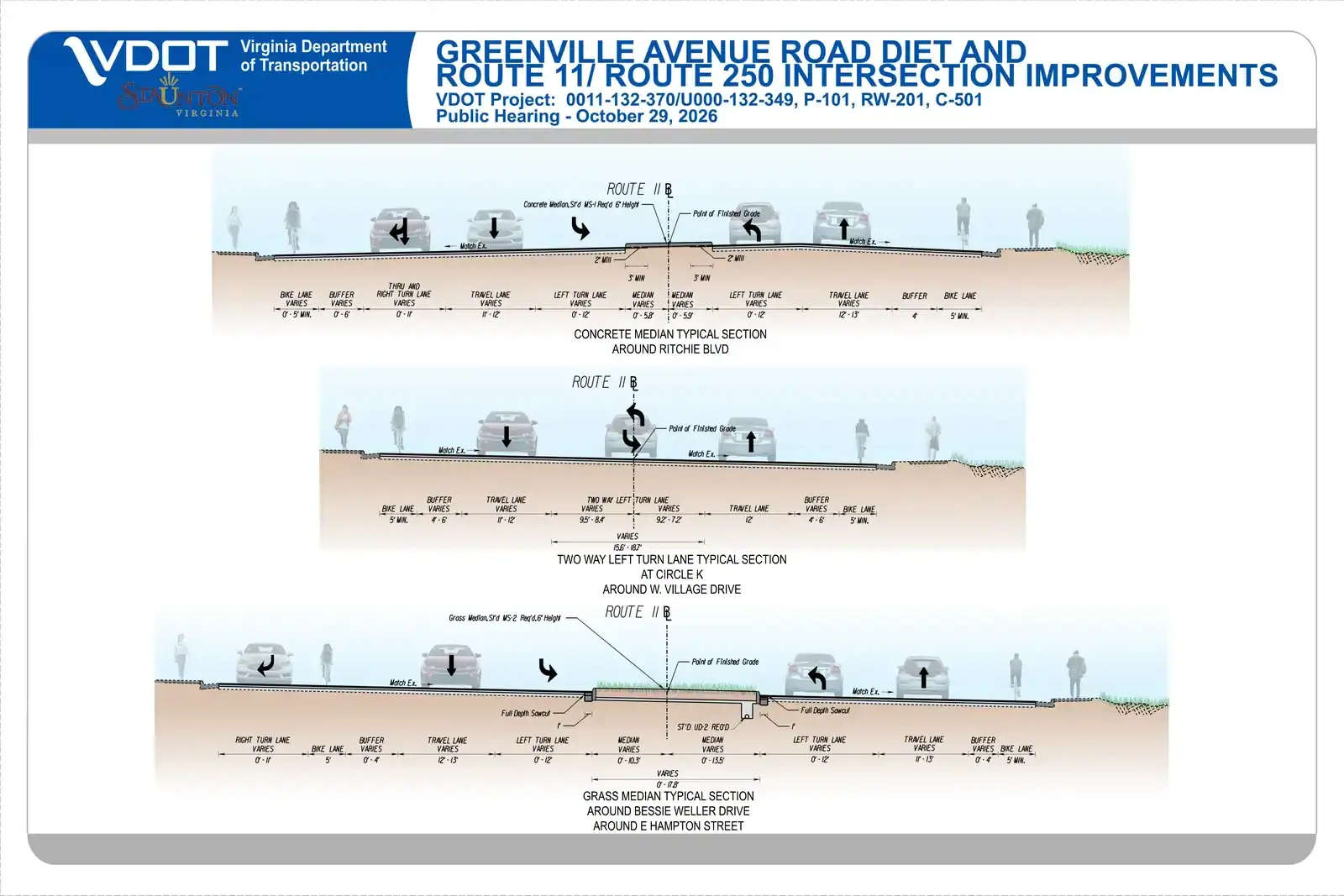
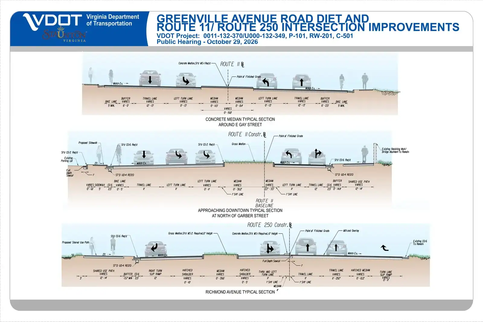
That’s a fair complaint, so here are the plan sheets. Tap any sheet to enlarge it.
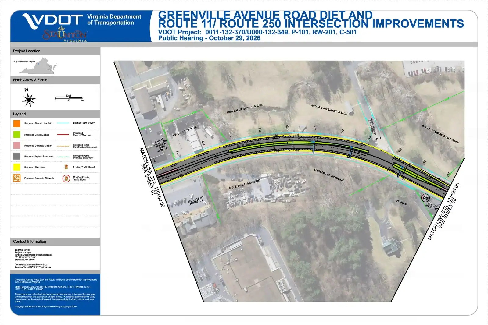
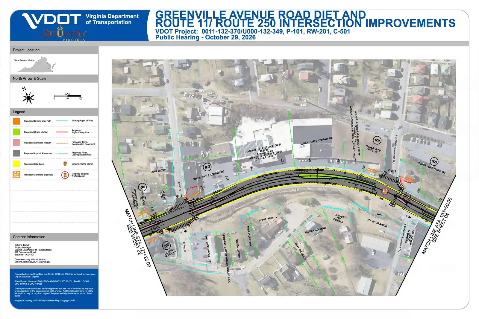
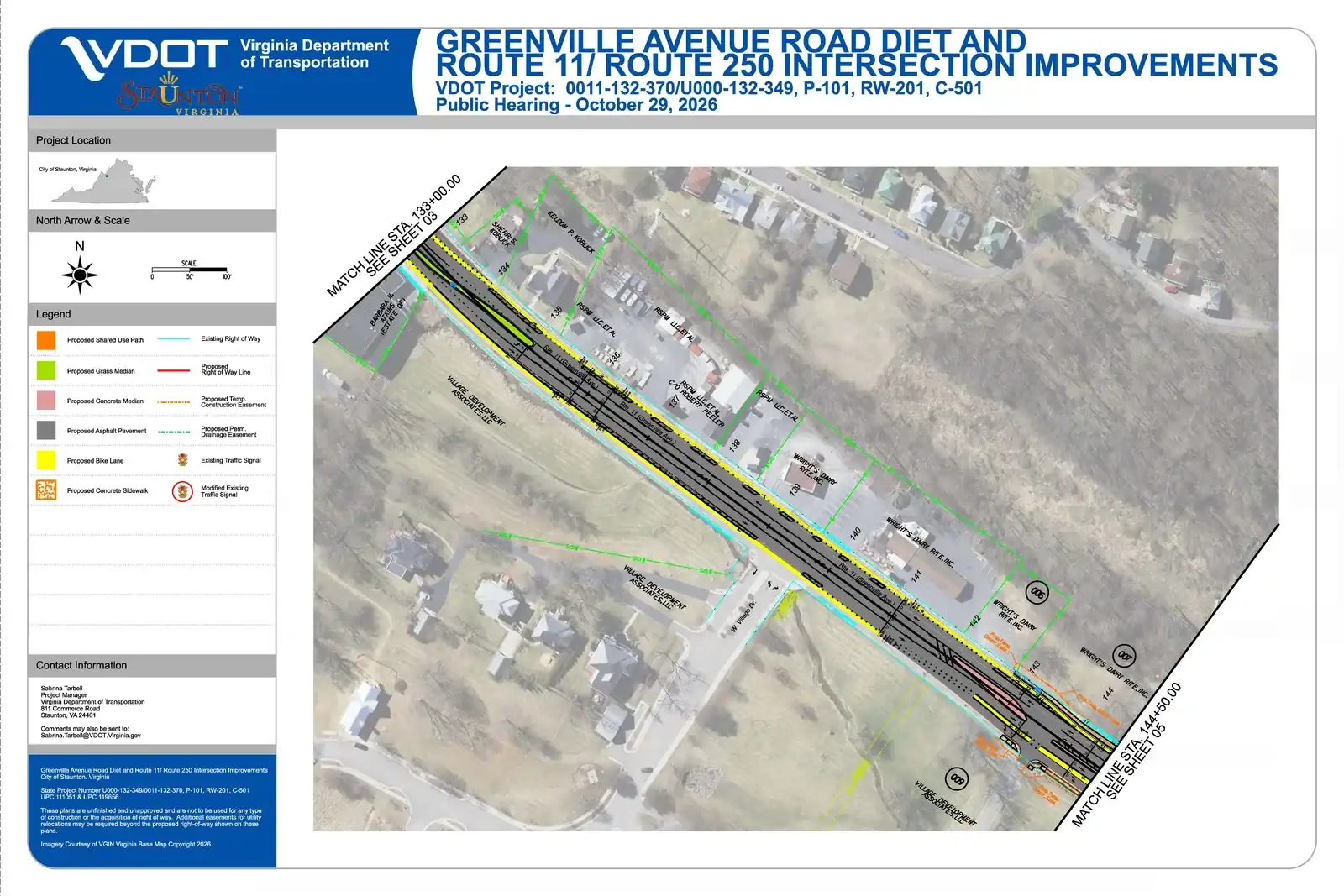
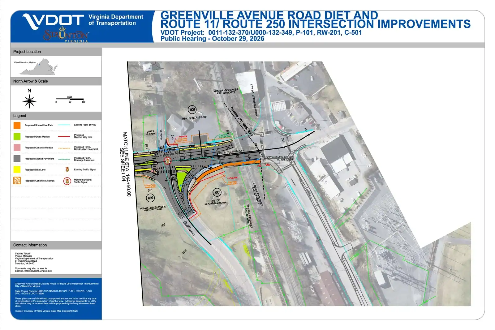
Sheet 1 of 5 (Statler and Ritchie Boulevards) and the full-resolution plans are on VDOT’s project page. Plans courtesy of VDOT, which notes they are preliminary and unapproved.
How can I support safer streets on Greenville Avenue?
Take VDOT’s survey before Sunday, November 8. It takes a few minutes, and every comment becomes part of the public record VDOT reviews before finalizing the design.
- Open the survey at publicinput.com/p56871 and choose “Provide project feedback.”
- Say you support the design as proposed, including the lane reconfiguration, medians, buffered bike lanes, sidewalks, and crosswalks.
- Add one personal detail. Name the place and the trip. For example: “I walk my kids to Bessie Weller and there’s no safe place to cross,” or “I drive Greenville Avenue every day and want a turn lane so I’m not rear-ended waiting to turn.”
- Prefer email? Send comments to VDOT Project Manager Sabrina Tarbell at [email protected] by November 8.
- Share this post with neighbors, your school’s parent group, and anyone who drives, walks, or rides Greenville Avenue.
Take VDOT’s Survey by November 8
What happens next?
After the comment period closes, VDOT will review public input and decide whether to approve the design as presented or with changes. Projects like this can be watered down when the record is mostly opposition. Your comment helps keep the safety features in.
At the Bike Walk Summit in Staunton on October 23, keynote speaker Charles T. Brown reminded the room that a single dangerous crossing can put an entire trip out of reach. Greenville Avenue has several. This project fixes them. Read the summit recap.
The Shenandoah Valley Bicycle Coalition builds and enhances trails on public lands, advocates for safer walking and biking, and connects communities across the Shenandoah Valley region. Learn more about the Coalition.
Tracking projects like this and turning out residents takes staff time. If you want more of it, become a TrailKeeper with a monthly gift.
Kyle Lawrence is Executive Director of the Shenandoah Valley Bicycle Coalition.