10/27: Update: Board of Supervisors votes to unanimously approve the first ever Rockingham County Bicycle and Pedestrian Plan. If you live in Rockingham County then please consider sending a THANK-YOU email to your supervisor. Don’t know who your supervisor is? Take a look at this map (Election Districts in Rockingham County VA) and then look at the corresponding County Supervisor here: Rockingham VA Boad of Supervisors
We have been talking about this one for many years now but the finish line is in sight and we want to be sure we sprint across it and break the ribbon together. After nearly four patient years, the time is NOW for better planning for biking and walking in Rockingham County (Also hopefully the start of more bike walk projects in our county)! The Rockingham County Board of Supervisors will hold a public hearing on the plan this October 26 from 7:00 to 8:00pm, at the Rockingham County Administration Center, 20 East Gay Street, Harrisonburg, Virginia. Hopefully, they will then vote to approve the plan!
Read the full plan: http://www.hrvampo.org/events/hrmpo-bicycle-pedestrian-plan-open-house
What: PUBLIC HEARING and (hopefully) Final vote to approve the first ever Rockingham County Bicycle and Pedestrian Plan
When: Wednesday, October 26 from 7pm-8pm
Where: Rockingham County Administration Center 20 E. Gay St. Harrisonburg, VA 22802
Why: If approved by the Rockingham County Board of Supervisors this would be the first ever biking and walking plan for Rockingham County. While the plan does not ensure that bike/walk projects are implemented, it does lay the groundwork and foundation to begin getting these projects on the ground. Without a plan, it is hard to encourage VDOT to improve biking and walking facilities on our county roads. It is also hard to apply for grants when the projects are not specifically identified in an approved plan.
Please Come OUT and show your POSITIVE support for this important step towards improving biking and walking in our region. While no plan is perfect, we ask that you support the plan and express your excitement that this level of planning has been achieved in our community. We especially want you to speak if you are a Rockingham County Resident!
Click the following link to review the Plan: Draft Rockingham County Bicycle & Pedestrian Plan
Please join us to hear more about the plans; there will be a brief presentation at 6:00PM. Refreshments will be provided.
The SVBC has been involved with this plan from the beginning. Read the backstory on the Rockingham County Bicycle and Pedestrian Plan:
- Original Action Alert in 2013 asking members and supporters to contact the Rockingham County Board of Supervisors. Read it here.
- Read about how the Shenandoah Valley Bicycle Coalition along with the DR100 kicked in $5,000 towards the creation of this bicycle and pedestrian plan. On the SVBC Blog.
- The Harrisonburg Rockingham Metropolitan Planning Organization Plan on the SVBC Blog
Samples from the plan: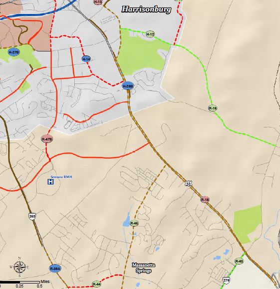
- Development of the Cooks Creek and Blacks Run Greenway Trails from the Belmont neighborhood through Dayton and Bridgewater and running north-south along Blacks Run to connect to the Bluestone Trail Cooks Creek and Blacks Run are small- to mid-sized perennial streams running through the southern portion of the HRMPO. Cooks Creek runs from near Mt Clinton Pike in central Rockingham County, south through the towns of Dayton and Bridgewater, meeting Blacks Run at Monger Park just north of Mt Crawford. The creek runs predominantly through rural areas of Rockingham County consisting of large parcels zoned for and currently in use as agricultural lands. Blacks Run begins in northern Harrisonburg and passes directly through the downtown area mostly below ground, passes through.
- R-44: Shen Lake Drive from Port Republic Road to Massanetta Springs Road – This sidewalk would provide a connection for pedestrians to the proposed shared-use path on Port Republic Road and enhance connectivity within the larger Shen Lake Community. A pedestrian crosswalk would be necessary to cross Port Republic Road to access the proposed shared-use path. The total length of the sidewalk would be approximately 0.74 mile in length and could be coordinated with the bike lane proposed along this same segment.
- The US 33 Corridor east of Harrisonburg was identified early on as a corridor in need of bicycle and pedestrian improvements because of the large amount of vehicular, bicycle, and pedestrian traffic utilizing this corridor for recreation and connections to important daily functions. US 33, is a 4-lane divided highway for most of its length east of the city. Between the city line and the community of McGaheysville there are no parallel roadways that offer options for these connections. Right-of-way in the corridor is approximately 180 feet including four 12-foot travel lanes with turn lanes at major crossovers, and a 64-foot median between them. There is approximately 50 feet of right-of-way on the north side of the road and an additional 10 feet on the south side. According to 2010 US Census data, there are 19,970 people living in the block groups that make up the US 33 East Corridor in the county.